WN Blog 023 – Indoor RTLS with WiFi and BLE – Deep Dive
20min read
Hey! Welcome to our latest WiFi Ninjas Blog 🙂 We’ve been busy lately testing some available RTLS solutions from a few different major wireless players and fell absolutely in love with the topic to the point, where we shake from overexcitement when thinking or talking about it ????
This summarises how we feel:
Excited Ninjas
Steve Jobs once said, “people don’t know what they
want until you show it to them”. He was right.
20 years ago, WiFi was “a nice to have”. 18 years
ago, paper maps were at peak of their popularity, until GPS receivers got small
enough to be put in the handheld devices. Is anyone not using Google Maps on
their mobile? 15 years ago, not many people felt they needed a wireless
headset, until Bluetooth was introduced. 7 years ago, NFC was a niche. Today,
most of us use contactless payments using cards, phones or watches.
Indoor wireless RTLS is at the early adoption
stage. Technology is available, we just need to make it more interesting and
rewarding to use.
Satellite-based location positioning services are
not always practical indoors. We could offer wireless RTLS functionality based
on WiFi, BLE or soon, possibly, Ultra Wide Band (UWB). Modern smartphones have
both WiFi and BLE radios built in. Additionally, new iPhones support UWB.
Wireless vendors leverage cell of origin, trilateration, triangulation, angle
of arrival, proximity and more with WiFi, BLE, UWB, GPS, NFC, mobile networks
or any combination of those methods and technologies, offering different levels
of accuracy and functionality. RTLS market is growing fast – according to
Bluetooth.com, 1.7 billion devices will use indoor BLE RTLS by 2023,
translating to even 500% increase in BLE RTLS implementations in some
verticals!
So, what do we need to see the RTLS market
explosion? We’ll be speculating, but our hearts tell us that indoor RTLS needs solve
real challenges like indoor wayfinding or call for help and simply be more
interesting not only for the business’ IT and marketing, but for everyone. We
also need more skilled wireless professionals willing to embrace broader
wireless technologies and emerging use-cases, like BLE and RTLS, on top of WiFi
design, security and analysis skills, while not forgetting about
programmability elements.
But enough of the babbling, let’s cut straight to
the juicy content! Here is what we will cover in this blog:
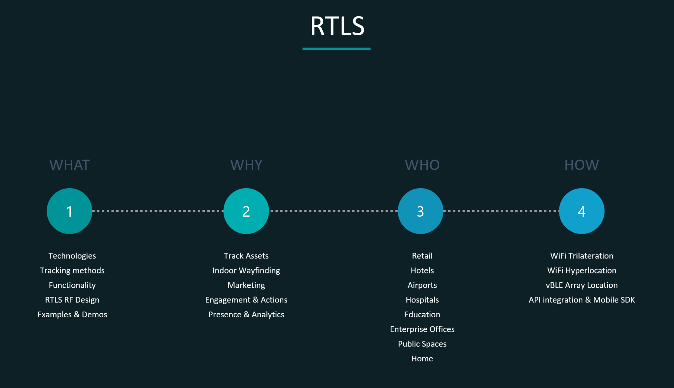
Blog Structure:
Theory
RTLS Technologies
WiFi
BLE
RTLS Tracking Methods
Cell of Origin
WiFi Trilateration
WiFi Angle of Arrival
Mist vBLE Arrays and Probability Surfaces
RTLS Functionality
Presence & Analytics
Location
Engagement & Actions
RTLS RF Design
Design Tips
Examples
Demo Time!
Test Environment
WiFi Trilateration
WiFi Hyperlocation
Mist BLE Arrays
Location API
Challenge 1 (Meraki Location API): Do You Need RTLS RF Design for WiFi Location & Presence Analytics?
Challenge 2 (Cisco CMX Location API): Can You Leverage Enterprise Messaging Solutions to Benefit from Indoor RTLS?
Gotchas
Theory
RTLS Technologies
WiFi
Most popular tracking technology, as it also provides access to the network.
Can offer different levels of location accuracy, depending on the tracking method used (cell of origin, Trilateration, AoA, etc.).
Multiple element antenna arrays can substantially improve location accuracy – Cisco Hyperlocation is a great example.
Can be used to track associated and unassociated probing clients.
Associated is proffered, since stations are chattier (with their screen on at least).
Normally, WiFi based RTLS is based on RSSI/Location information from probe requests only, as probing client normally sends requests on multiple channels, and is therefore seen by multiple APs. This, however, results in very infrequent location calculation ranging from 10 seconds to 5 minutes (according to Cisco) but our own tests shown that modern unassociated stations don’t probe at all. Note, that happy (high RSSI/SNR) associated client probably won’t probe at all, and therefore its location could not be calculated with better accuracy than ‘cell of origin’ (see below) until its re-associating (roaming). Cisco has addressed this challenge with a feature called ‘FastLocate’. It uses a dedicated built in antenna array (4800) or a halo module (3600 / 3700) to scan multiple channels and get RSSI values from clients’ data packets across multiple channels without sacrificing performance of clients serving radio by going off-channel to do just that.
To track unassociated station, two conditions must be met: station must not use MAC randomisation (they normally do) and it must be probing. Not all unassociated stations are probing.
Client apps are optional and can be used to increase tracking accuracy, location calculation frequency and add engage or actions element. Note, that using mobile SDK in WiFi-based RTLS is challenging, as the application normally has no way of knowing the MAC address of the device it sits on.
On top of location analytics, WiFi is normally used to provide presence analytics (more info below).
BLE/vBLE
BLE relies on physical
beacons, often battery operated; vBLE moves beacon role from BLE beacons to APs
.
BLE is often used to
offer proximity-triggered actions and vBLE can be used for location analytics
on top or instead of WiFi
Client app is required
for fast (sub-second with Mist) and accurate (1-3 metres) BLE/vBLE. Station
listens to the BLE transmissions coming from the BLE AP (BLE APs are
transmitting). Mobiles listens to all (directional with Mist) beams from all BLE
APs in the area and sends RSSI values with beams ID to the server/cloud, where
location engine will calculate station XY coordinates and send them to the
station. Note, that mobile station can send that information using mobile
network; device doesn’t have to be associated using WiFi for BLE RTLS to work.
Clients with no apps
will be treated / located as BLE tags / assets. In this scenario, client is
sending BLE transmissions to BLE APs (BLE APs are receiving). Mist uses its
directional arrays to pinpoint asset tag transmission location with
mind-blowing accuracy, all other vendors will typically rely on tag proximity
to BLE radio built into the AP / anchor.
More BLE beams heard =
better accuracy.
More element antenna
arrays can substantially improve location accuracy – Mist BLE Arrays are a
great example.
BLE seems to be very
well suited for RTLS, as it doesn’t travel as far as WiFi, therefore offering
theoretically better accuracy than WiFi. Note that both BLE (2.4GHz) and WiFi
(2.4 or 5GHz) are using the same frequency (actually WiFi can even sit on a
higher frequency with 5GHz, and therefore theoretically not travel as far as
2.4GHz) but BLE (Bluetooth LOW Energy) uses significantly lower power levels to
operate.
XY coordinates are
calculated for vBLE and are typically not calculated for BLE (proximity used
instead, but there are exceptions to that rule!).
RTLS Tracking Methods
Cell of Origin
Simplest location technique.
Typically leveraging location of AP that clients are connected to but might be the AP that sees the probing or associated client with strongest RSSI.
Great for simple zone-wide accuracy.
Requires at least 1 AP per zone and careful RF design.
XY coordinates are not calculated.
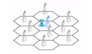
WiFi Trilateration
Distance (lateration) based location technique using RSSI in 802.11, measured by either STA or AP/Sensor.
Adds more accuracy within a zone (tested with Meraki and Cisco) – 2-3m labbed (in perfect environment), 5-7m marketed, 7-10m real.
Real accuracy is lower than labbed and marketed, as it’s difficult to have LOS between 3x AP and STA everywhere. Also, cross floor leakage, atriums, walls and signal deterioration – all affect accuracy.
Note, that we normally use Trilateration in WiFi RTLS and it’s often confused with Triangulation.
Trilateration: requires 3 APs with known distance between them; uses RSSI (distance, lateration) to calculate intersection (client XY coordinates) between three circles (as shown above).
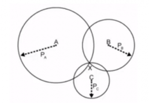
Triangulation: requires at least 2 APs with known distance between them; uses this baseline and multiple-element antenna arrays (that we typically don’t have in WiFi APs, with Hyperlocation being exception here) to calculate arriving signal angles to find XY coordinates of the client (as shown below).
XY coordinates are calculated.
WiFi Angle of Arrival
AoA (angulation) location technique using angle of incidence at which STA signals arrive at the receiving sensors.
Requires at least 2 APs / sensors / modules (at least 3 recommended for better accuracy).
Note, that AoA with three APs is in fact a tri-angulation.
Requires multiple element antenna arrays or antenna mechanical agility.
Cisco Hyperlocation uses a mix of WiFi Trilateration (RSSI), WiFi AoA and BLE
Cisco 3600/3700 Hyperlocation module has 32-element antenna array
Cisco 4800 built-in Hyperlocation has 16-element antenna array
According to Cisco, Hyperlocation module used with older APs and 4800 built-in array offers same levels of accuracy
AoA is more accurate than Trilateration (tested with Cisco Hyperlocation) – 1-3m labbed, 1-3m marketed, 1-5m real
Real accuracy is lower than labbed and marketed for similar reasons as discussed for Trilateration. Additionally, AoA requires extremely careful mounting and calibrating APs positions in maps services (height, azimuth).
XY coordinates are calculated.
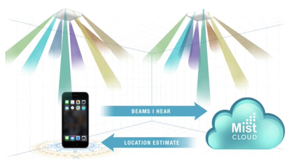
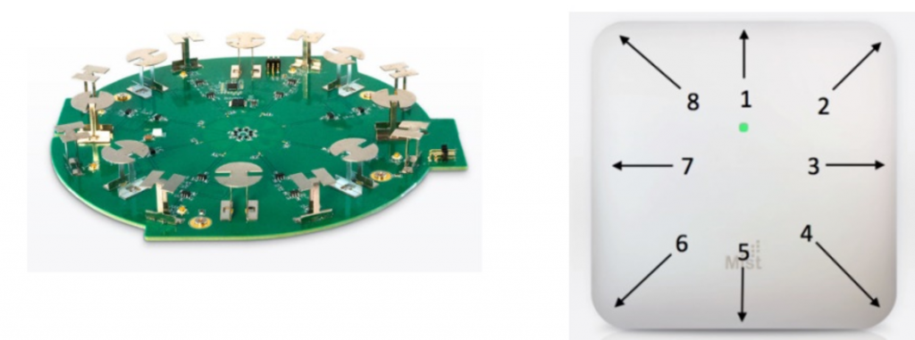
Mist vBLE Array and Probability Surfaces
Unique to Mist.
Every Mist AP has 16 Directional
Antennae Bluetooth Array – 8 reflectors and 8 directional antennas.
Uses BLE concept,
where Mist SDK on the mobile device is listening the beacons from the beams and
sends the RSSI and device sensor information back to the Mist cloud through
either WiFi or cellular. Mist also supports assets tracking.
Mist is not using standard
Trilateration, but ‘Probability Surfaces’, where combination of listening to
directed AP Beams and machine learning constantly evaluating Path Loss Formula
(PLF) per device to calculate station location.
Extremely good
accuracy: 1-2m labbed, 1-3m marketed, 1-3m real (mind blasting).
XY coordinates are
calculated.
RTLS Functionality
Presence & Analytics
Typically relies on WiFi
Provides network level stats, such as:
Current visitors: devices count, dwell time, gender and age split, device types present
Avg. visit distribution: time of day, day of week, new vs repeat, duration, gender, age
Bounce rate (stayed vs bounced; enter and stay for longer than 3 min)
Conversion rate (converted vs passed; clients that passed the venue but didn’t enter)
Visitors engagement ratio (stayed connected over specified time)
We can leverage social media, mobile apps or splashpage forms to onboard WiFi clients and grab users’ details (be careful with GDPR!)
Location
Typically relies on WiFi, BLE/vBLE, GPS, Mobile, UWB, Ultrasounds
Provides zone/location level insight, such as:
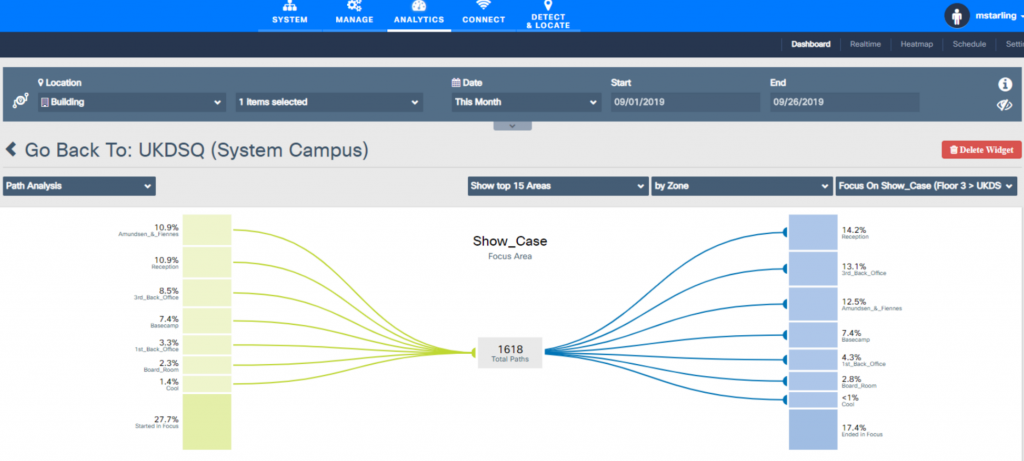
Zone analytics & zone paths
Location on the map (dashboard or client app – blue dot)
Some location features can be leveraged directly through specific web user interfaces (CMX, Purple, Mist or Meraki Dashboards) but it’s generally more powerful and useful to get, manipulate, filter and visualise location data using API – output can be crafted to any business needs. Typically, the following attributes can be grabbed (or subscribed to if you’re using Mist Webhooks) via location API:
Zone analytics is extremely valuable for businesses, especially retail, to understand impact of their actions (new displays, stands, brands, promotions, etc.) on paths users are taking and stats for each zone (dwell time, count, etc.)
CMX GUI – Zone Paths example:
Purple GUI Zone – Paths example:
Engagement & Actions
Uses Presence, Analytics and Location insight to create personalised user experience
Example 1:
Returning user that has opted in and has previously bought a pizza (tagged with ‘pizza lover’ tag) entering 1st Floor dining area after 3.15pm will get a 50% off offer delivered via App Push Notification (This would also require some CRM integration)
Example 2:
When user is in a proximity to a BLE beacon or a vBLE area, open wifininjas.net website in a loyalty app integrated browser
Example 3:
Zone A (sports cars) will use different Captive Portal than Zone B (donuts)
Example 4:
User uses app for indoor wayfinding – where am I and how can I find client X reception and how to get there?
Example 5:
User requires assistance in the shop (looking for a certain size of shoes to try); user can use the mobile app to ‘call for help’ and grab attention of staff; staff knows where to find a client calling for assistance as they also use location-aware mobile app
RTLS RF Design
Design Tips
APs should be located around zone perimeters to create a convex hull
Each client should be within convex hull of at least 3 APs with solid RSSI (-65dBm is OK)
It’s ideal for all tracking methods, even though AoA and Mist BLE require just 2 APs to work; still, more APs give better accuracy
Ideally, use dedicated radio or module for RTLS to maximise location scanning performance and minimise performance impact to client-serving radios
Ensure LOS is maintained between APs and clients (AP behind ceiling tiles is a no-no)
Don’t mount APs too high! Not more than 4.5m is OK
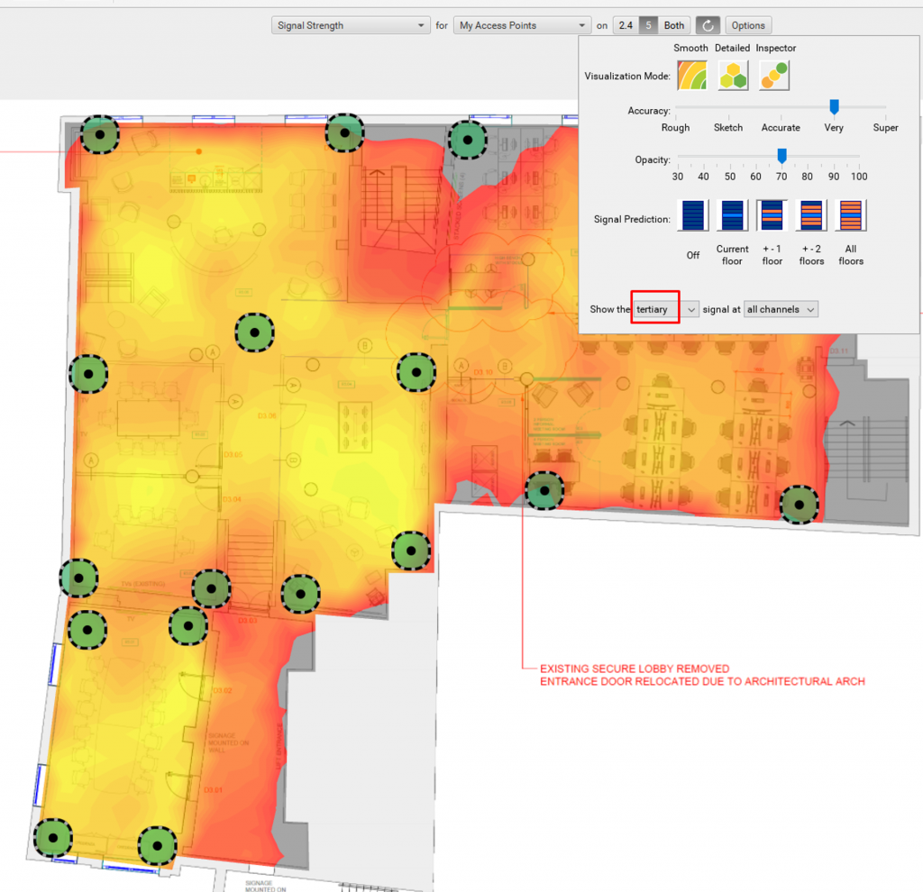
Validate secondary and tertiary signal strength in your favourite survey tool
Cisco specific:
Enter thick walls into Prime and ‘Enable OW (Outer Walls) Location’ in CMX to use it for calculation
Always use FastLocate functionality (leverage client data packets and probes to calculate location)
Examples
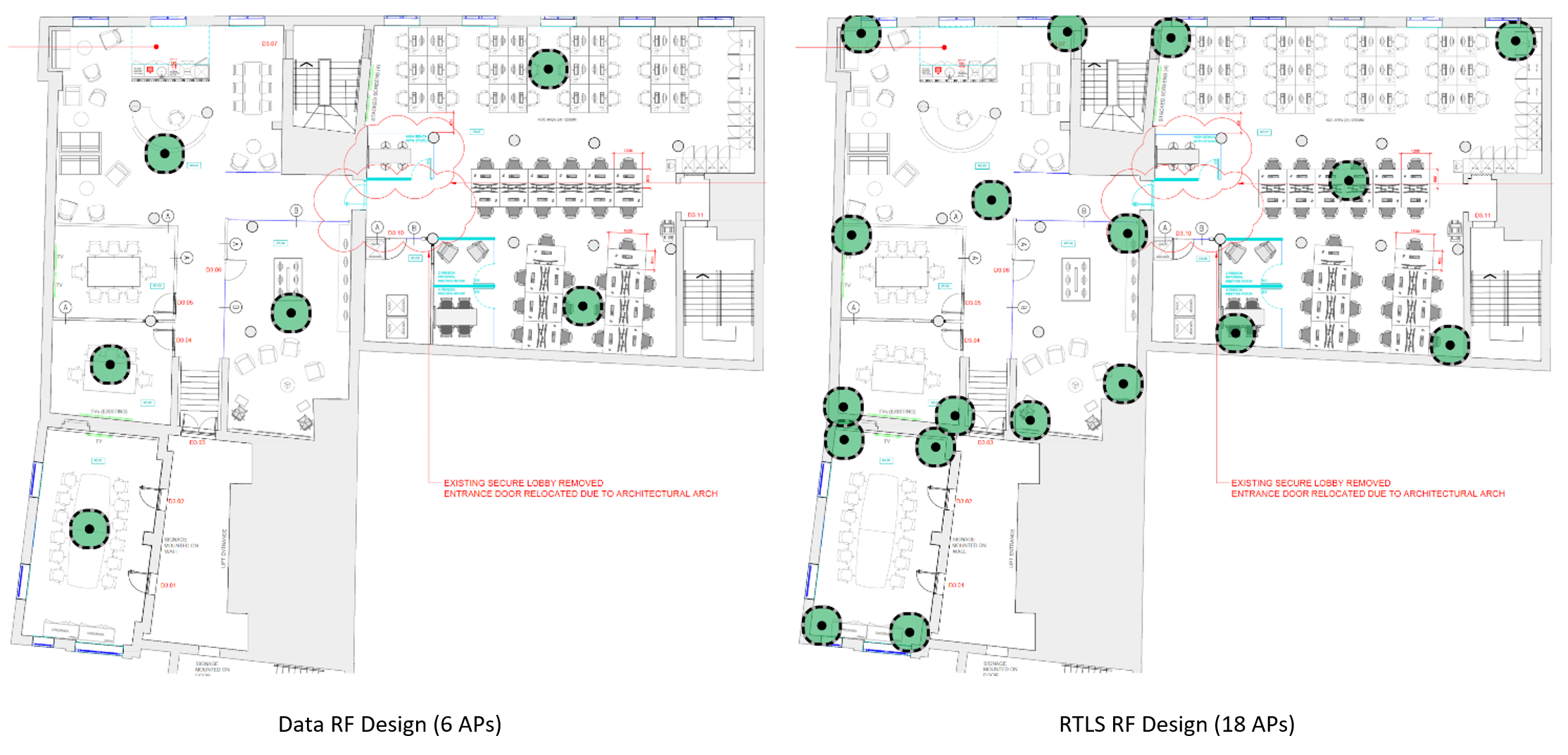
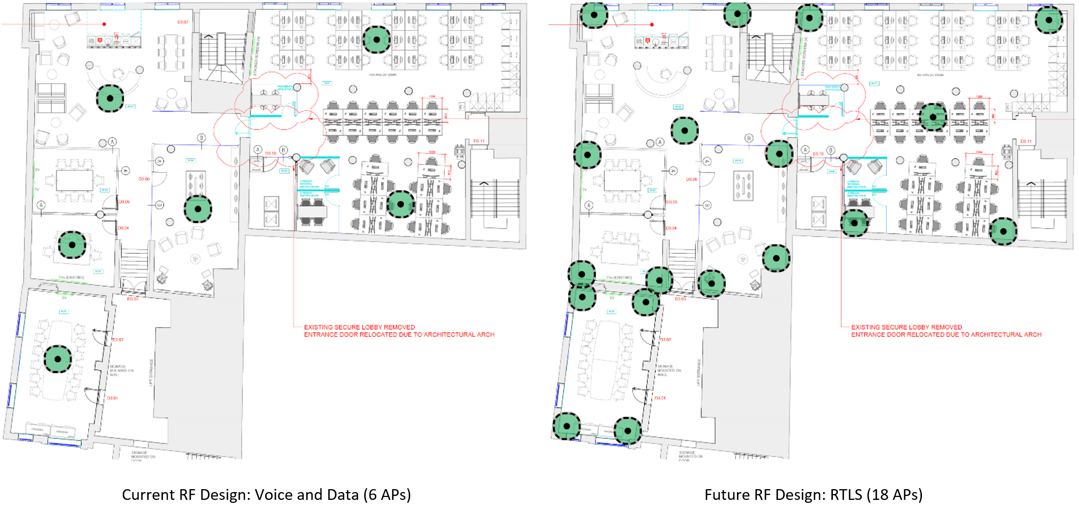
Note, that number of APs has tripled!
Generally speaking, if the design is good for RTLS, it’s also good for any
other use case (data, voice, most high-density scenarios, etc.). Sometimes some
WiFi radios need to be put into non-client-serving mode as too much WiFi can be
damaging to the performance of the network (topic for a different discussion).
Demo Time!
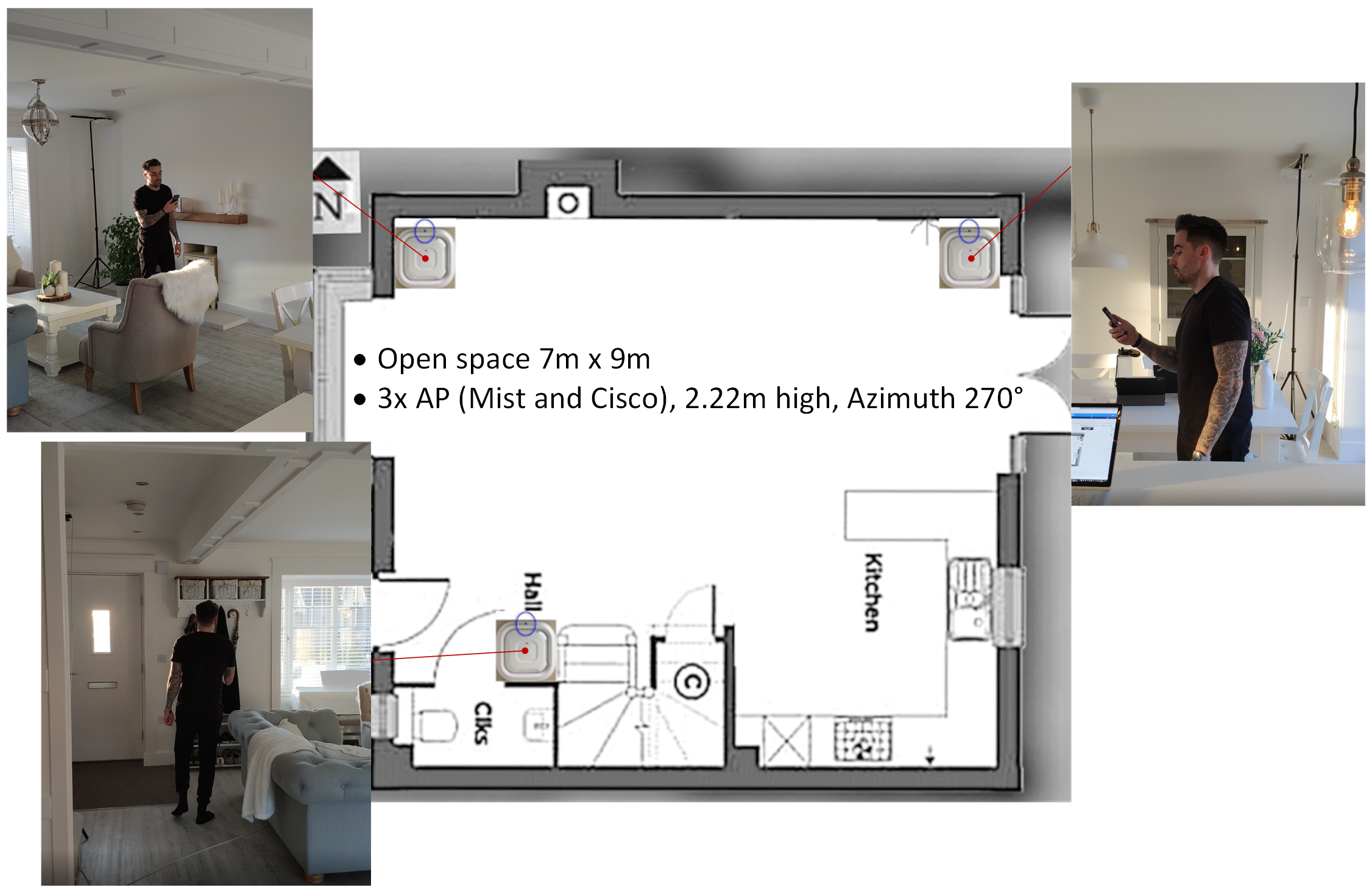
Test Environment
All APs were positioned quite nicely, LOS with a client maintained everywhere within a convex hull making it slightly unrealistically great (normally possible in lab environment only).
Laser tool was used to measure height of the APs.
WiFi Trilateration
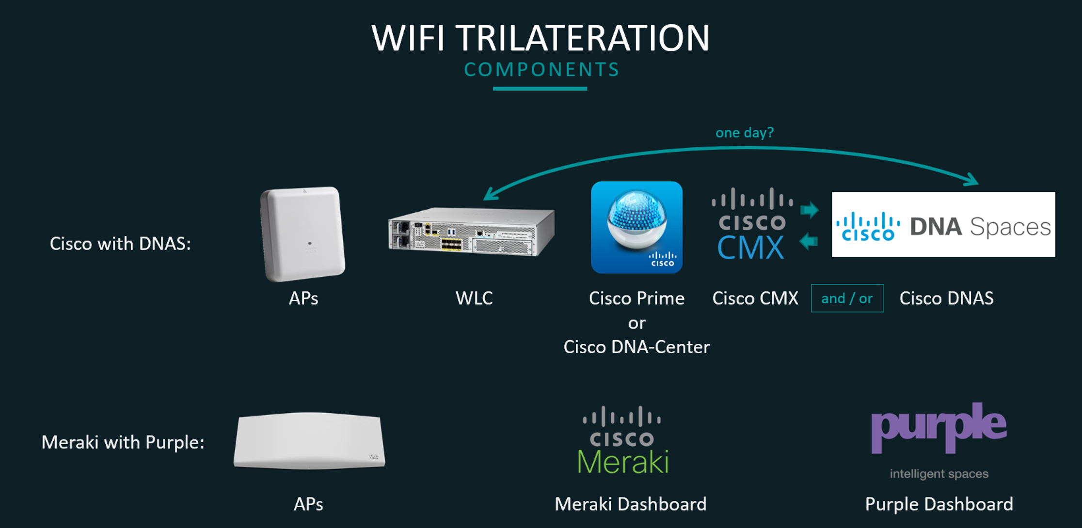
Components
Tested with traditional Cisco and Cisco Meraki
We have deemed Meraki Dashboard unusable for RTLS (shows only point of association and overlays all clients from all floors on every floor map) so we’ve also used Purple as an RTLS Dashboard overlay with Meraki testing
Prime (or DNAC) is needed to create maps, place APs, set their height, azimuth, specify zones, inclusion & exclusion areas, walls, rails (wayfinding paths)
Theoretically CMX is not required if Hyperlocation is not in use and we could connect AireOS or C9800 WLC directly to the DNAS. Unfortunately, we couldn’t do it as:
Direct connection requires DigiCert CA Root Certificate that we don’t have on the WLC
C9800 code version 16.12.2 is required, but 16.12.1 was newest publicly available at time of testing
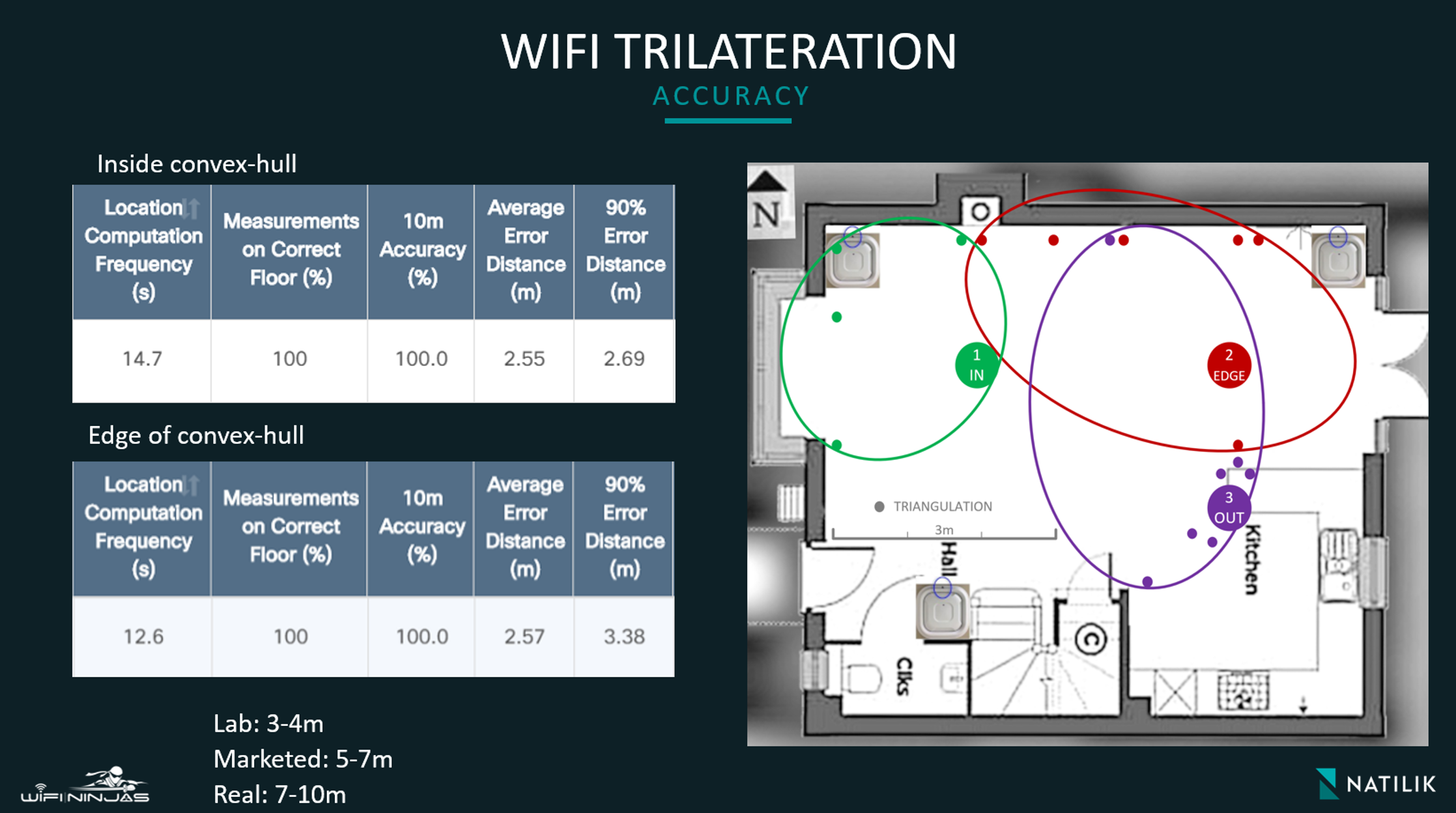
Accuracy
Theoretical expected
accuracy of 5-7m
Better than expected
accuracy when inside the convex hull (2.55m average; 2.69m 90% error distance)
Still good accuracy
when on the edge of the convex hull (2.57m average; 3.38m 90% error distance)
Location Computation Frequency
of 11-15 seconds (with screen on, associated and active device) is not enough
to offer blue dot experience but it’s still good for basic RTLS functionality like
simple, static wayfinding or zone analytics with zones sized accordingly to solution
accuracy
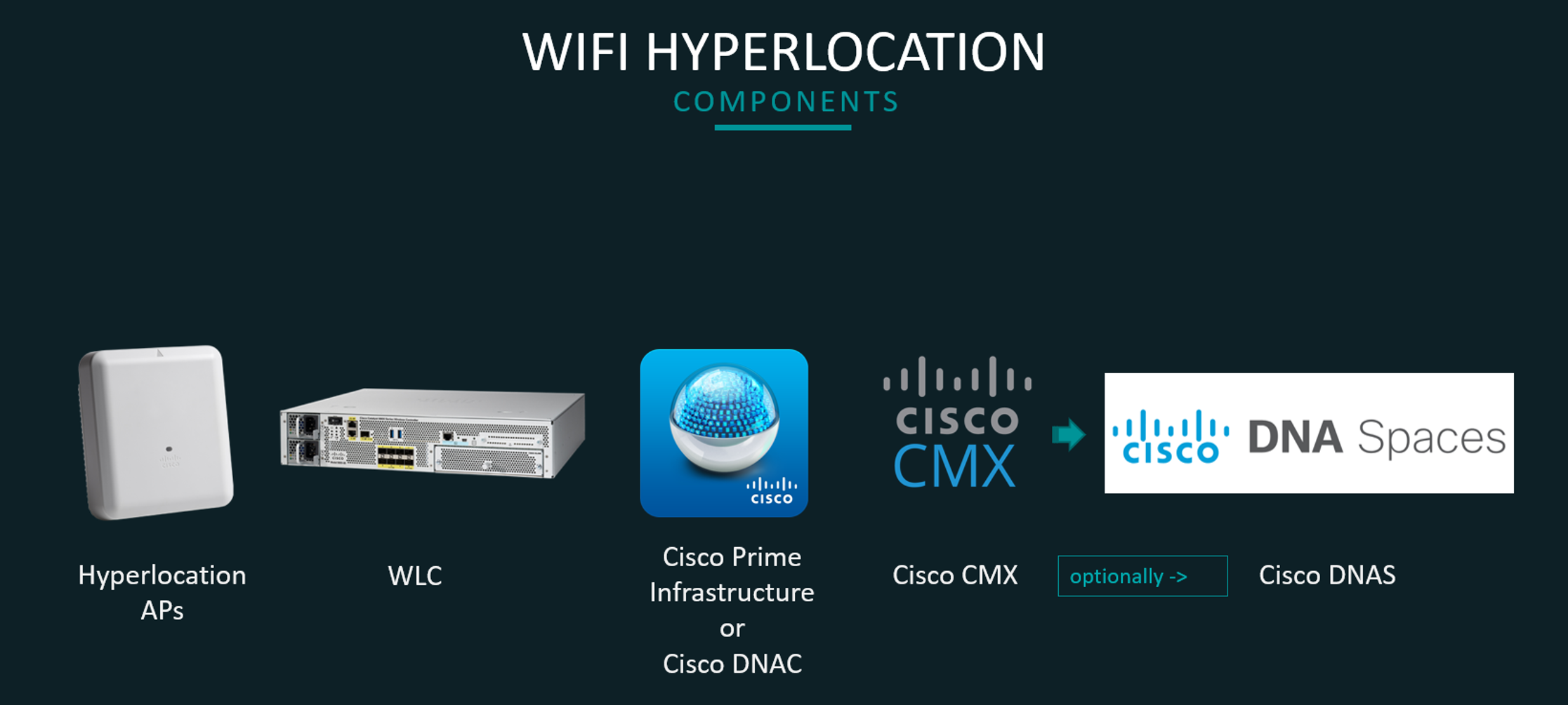
Cisco Hyperlocation
Components
Prime or DNAC still needed for maps
Overall complicated setup, prone to user errors and bugs
CMX on-prem required to do all data crunching – it’s quite a lot of data to go through!
DNAS can be used to access presence, analytics and location data in the cloud if required
Note, that at the time of testing DNAS was lagging behind CMX and was generally slower and less accurate than CMX!
DNAS can also be used for many more things, like integration with 3rd party tools or Open Roaming integration (amazing idea that we feel will change the way we use public WiFi – let’s leave it for a future blog ????)
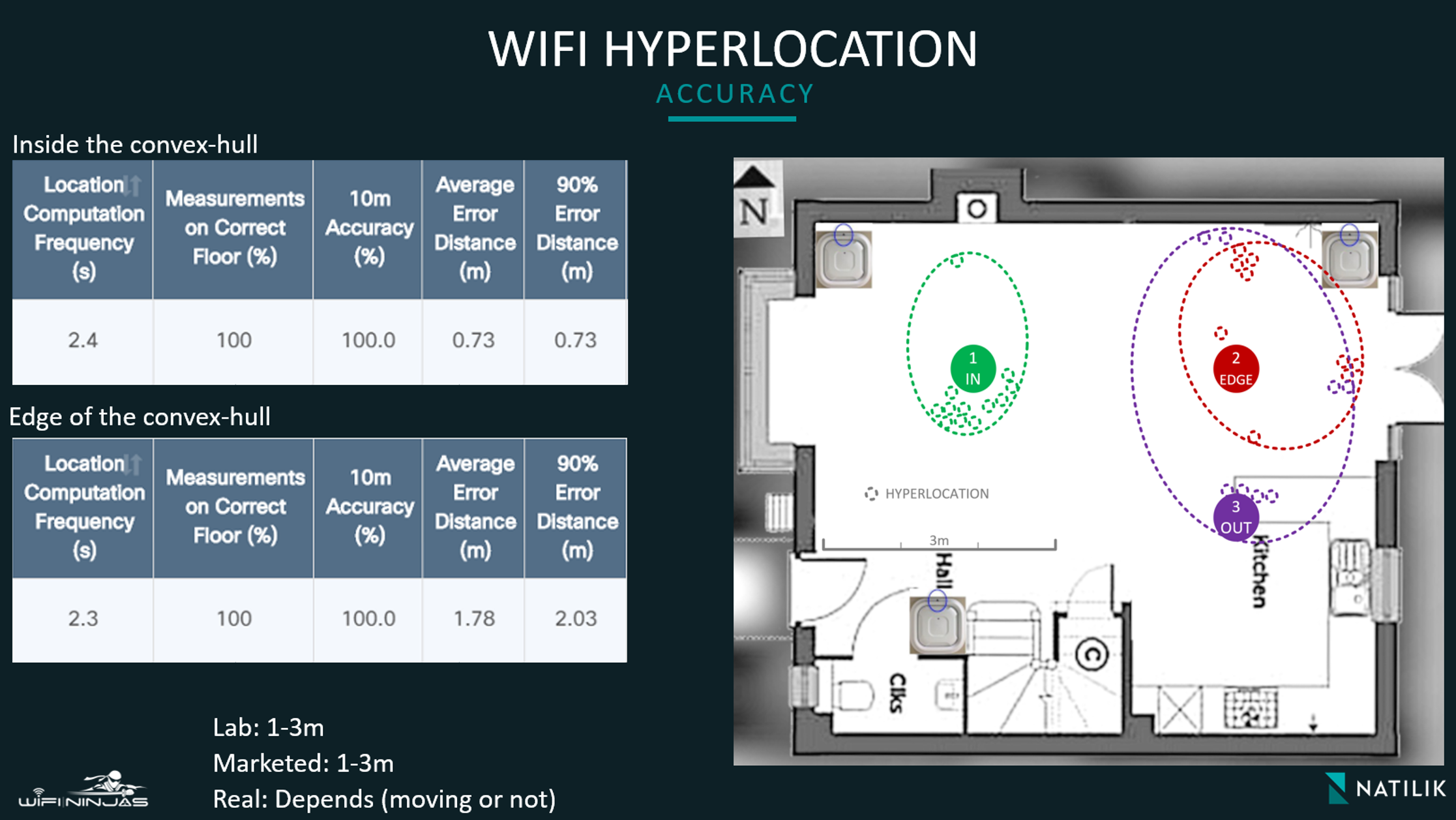
Accuracy
Theoretical expected
accuracy of 1-3m
Totally brain smashing
accuracy inside the convex hull (0.73m average; 0.73m 90% error distance) for a
non-moving client
Good accuracy at the
edge of the convex hull (1.78m average; 2.03m 90% error distance) for a
non-moving client
Note, that accuracy of
mobile clients will depend on their speed of movement and since location
computation frequency is 2.3-2.4 seconds at best, the distance travelled within
that timeframe will be typically added to the calculated location error
distance
Demo
Let’s look at the
video showing CMX app, CMX Dashboard and Matt walking around my house ????
Accuracy is generally really good!
Blue dot location update (location calculation
frequency) of 2-3 seconds is not bad and should be enough for most indoor RTLS
use cases.
We didn’t draw rails (wayfinding paths) in Prime
so what we’ve seen here is raw XY calculations displayed on the map. Rails around
the path Matt’s taken would snap him into it, making blue dot appear more
accurate.
CMX has great zone path visualisations built in
and it’s generally a rarity (Purple also has it built in and it’s as good; note
that not everyone will leverage GUI-based zone paths analytics since we can use
API and visualise it ourselves and integrate it with existing tools but it
requires clearly defined requirements and solid skills and effort).
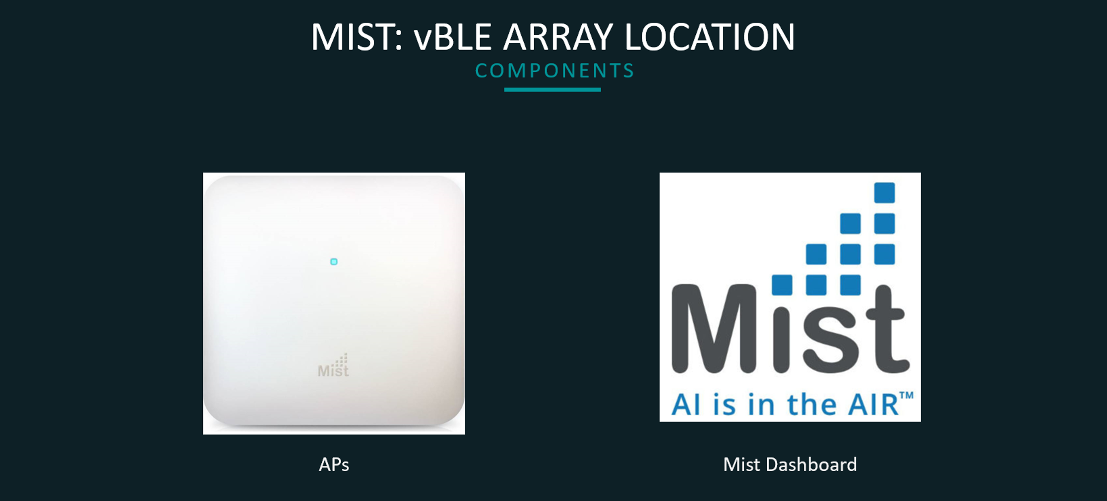
Mist: vBLE Array
Components
Yup,
that’s it ???? Class leading simplicity. We’ve had a lab
running by lunchtime and never had a chance to play with Mist before!
All maps management,
wayfinding paths, beacons and zones done easily in the Dash.
Accuracy
Less than 1m inside
the convex hull.
Reliable sub second
Location Computation Frequency when used with an app, making it difficult for
other major WiFi vendors to compete with.
Demo
The video screams
million words! Let’s take a look ????
Absolutely
mind-bending accuracy with quickest location computation frequency we’ve seen
to date in indoor RTLS space!
It is expected to
still use WiFi to get network-wide presence and analytics stats, despite using
BLE for location.
Mobile app is required
for the proper BLE solution to work (might not be a bad thing, since mobile app
is required anyway to get the most of any indoor RTLS solution, despite the
technology used).
Mist has no zone path visualisations
built in (we only have basic zone analytics) – it’s expected to leverage API to
access / visualise this data.
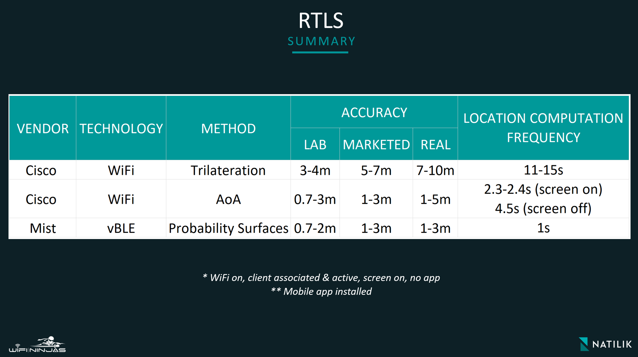
Accuracy Summary
Below is a quick summary showing results of our tests for different
indoor RTLS solutions!
Location API integration with existing infrastructure – two examples!
Meraki API – Cell of Origin Example
Background
We have recently worked on project for a beautiful,
listed retail store in London, where following a very successful design and
implementation of Meraki data WiFi network in the store, retail RTLS topic has
emerged. With RF design crafted for data, we have faced a very real
challenge – would the existing placement, type and number of APs be useful
for indoor Real Time Location Services with a zone-level accuracy?What
would be the challenges, limitations and reasonable expectations in
terms of RTLS usage and accuracy? Could Meraki API help achieve
goals set by the business?
Challenges
RTLS was
not in the original scope and, combined with a store physical environment, we
have faced some challenges:
RF Design: the network was designed with data in mind. We didn’t have APs
placed on the outside coverage zones’ perimeters, had just 1 or 2 APs per zone
in most areas and proved with a detailed WiFi survey/assessment that zone
accuracy leveraging WiFi trilateration should not be expected.
Physical Environment: the building was listed, APs/antennas
mounting options limited, walls and ceiling mostly wooden, with very low
attenuation. All three sections (east, west, central) had big atriums
contributing to cross-floor RF leakage strongly. Building had 6 levels.
Vendor Choice: we had Cisco Meraki and Purple already in place. Purple
leverages Meraki API and uses Meraki pre-calculated XY coordinates (this can’t
be changed) to display users’ location on the map. With data design, we didn’t
have enough APs per zone to rely on the Meraki XY coordinates. Trilateration
requires min. 3 APs in a zone to work reliably. Normally, we would have just one
best AP (strongest RSSI) in every zone, with additional two APs needed for
trilateration being located in adjacent zones or even a floor or two away! This
has contributed to wildly inaccurate location readings in Purple
(approx. 22m 90% error distance, often on a wrong floor) and could not be relied
on. Note, that network-wide WiFi-based Presence & Analytics stats were
perfectly reliable.
Floor
diagrams below show the difference in RF Design for Data (what we have) vs RF
Design for RTLS (what we would need for WiFi Trilateration to work):
Expectations
Based on
the additional very detailed survey (more than 100 test locations across
multiple floors with 3 different device types: flagship Windows 10 laptop,
Android phone and iPhone), where we temporarily installed several new APs on
tripods, we concluded that achieving satisfactory and reliable zone-location
accuracy (10m 90% error distance) using
WiFi trilateration would require to approximately double the number of APs.
The business has decided not to install additional APs and knowing that
a mixture of Meraki and Purple could not offer reliable location insights and
that WiFi trilateration would not be practical to use at all (because of the
design, regardless of a vendor), we looked for alternative solutions and
new success criteria were defined:
Location analytics with zone accuracy was the new goal; access to zone-based stats &
clients’ paths deemed critical.
Zone sizes were increased; sometimes a zone would be as big as a 30x20m
open space, sometimes as small as 8x8m room.
Still use Purple for presence & analytics, guest splash
page & social media integration.
Solution
We have gathered some facts: data & voice performance over
WiFi, capacity, coverage and roaming were all rock solid across
all WLANs (MAB/CWA for guests and EAP-TLS machine auth for corp) and for all
test devices (company issued laptops, major OSes, newer and older phones). High
density areas, like ground floor entrance hall, could get very busy during
holiday periods (200+ associated devices in a small 15x20m area) and were
covered by three high-gain dual-band sector antennas. 5GHz was almost
free of channel contention with careful APs placement around atriums and use of
properly tweaked RF Profiles: 20MHz channels width, limited max and min
Tx power, disabled data rates of 11Mbps and lower. 2.4GHz was tweaked even
more, with several APs having their radios off and max Tx power set to the
level, where RSSI was generally lower on 2.4GHz than on 5GHz throughout the
store and only OFDM rates were allowed. 2.4GHz was still considered best
effort. Presence & analytics with Purple was spotless.
Switching focus to location zone analytics, we have confirmed
with a detailed post-deployment survey, that our test clients were reliably associating
with APs installed in the zones they were in. WiFi scans from unassociated
devices taken in multiple spots in each zone revealed that we could use
strongest RSSI reading from one best AP to accurately pinpoint the probing or
associated device to the zone it was in. We concluded that we could potentially
leverage two attributes to correlate WiFi devices with their current
zones:
Associated devices
only: use MAC address of the AP the device
is associated with.
Associated OR
unassociated probing devices: use MAC address
of the AP that reports probing or associated device with strongest RSSI.
Two things to note:
WiFi MAC
randomisation makes it impossible to track unassociated devices that use
it.
New mobile
platforms battery saving modes make those devices very quiet – they
often won’t probe at all.
To further simplify our zone analytics calculations, we have decided to
use just one attribute moving forward – MAC address of the AP that
reports the probing or associated devices with strongest RSSI.
We have discovered that it is possible to get the RSSI attribute
for every client seen by all near APs with Meraki API location
data. Readings are provided every minute and contain RSSI values covering last
60 seconds. While it’s not very fast and could not be used for a blue dot
experience, it is enough for our use case – historical view of zone paths and
analytics.
Using strongest RSSI proved to be 95% accurate across entire
building and 100+ test spots when correlating user (reporting AP)
location with a zone.
Raw Data from Meraki API – note ap_mac,
seen_time, client_mac and RSSI
As we know exactly which zone all the APs are installed on, we could
easily generate reports showing clients paths with zone accuracy,
time spent in each zone, number of clients per zone, etc. without
relying on wrongly pre-calculated Meraki XY coordinates.
To automate the zone paths visualisation and zone analytics, client’s
software development team has created a tool to do just that. At this
point, imagination was the limit.
Conclusion
Sometimes we are limited by a solution functionality when trying to meet
client’s requirements. In our example, Purple could only use Meraki
pre-calculated XY coordinates and it was not practical or accurate enough (even
for a zone-wide accuracy) to use with a data / voice RF design. Let’s answer
our initial question. Do You Need RTLS RF Design for WiFi Location, Presence
& Analytics? Short answer is “no” for presence & analytics
and “it depends” for location. Presence & analytics provide us with
network-wide stats, without the location awareness and therefore will not require
RTLS design. Location, however, requires very careful RF design to provide
different levels of accuracy. With a solid data RF design, where
association and roaming trends are reliably predictable, we could expect solid zone-wide
accuracy. Anything more accurate (trilateration, Hyperlocation, vBLE) would
require more APs, detailed survey, RTLS RF design, careful placement of
APs/antennas and pedantic maps services configuration with spotless APs
positions, height and azimuth set.
Cisco CMX API – Location Analytics integration with WebEx Teams Chatbot
Example
Background
At Natilik, we’re currently
in the process of upgrading our showcase with Cisco DNA. The plan is to have
full SDA Fabric, C9800-based Fabric Wireless, proper RF design with Cisco 4800 APs,
CMX and DNAS in one part of the office and a mixture of AP43 with BT11 in the
other part. We’d love to not only showcase Cisco Hyperlocation and Mist BLE
Arrays in action, but also leverage the tech to offer indoor wayfinding with
turn by turn navigation and onboard guests using Hotspot 2.0 (called Open
Roaming by Cisco) for our visitors WiFi.
As of today, we don’t
have the new showcase fully running yet, so all we have to play with is ‘standard’
corporate WiFi design for Voice and Data.
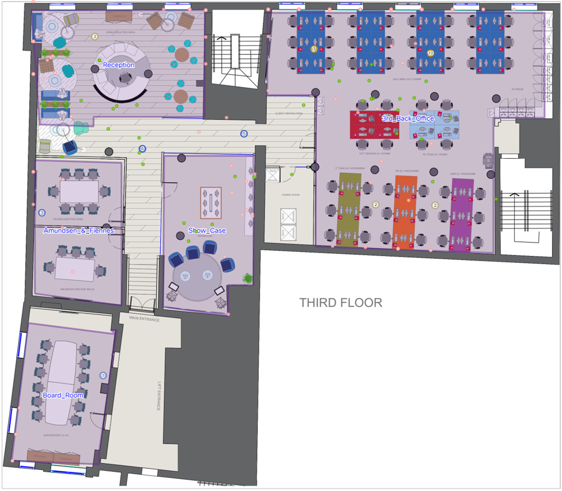
The above shows one out
of the two floors we occupy. With current design, all we can use is Cell of
Origin and, around reception, WiFi Trilateration. And that’s it. Location
Calculation Frequency of 11-15 seconds is not enough to offer blue dot
experience, but we thought it could still be good enough to solve some
wayfinding challenges!
Challenge
We have Cisco AireOS Wireless
with CMX, Cisco WebEx Teams and everyone has a corporate phone enrolled with
Meraki MDM.
We would love to use the
kit we have today to locate a colleague, zone or a meeting room by asking WebEx
Teams chatbot about the location of person/location we’re after without the
need to install the mobile application, as we can’t have a turn-by-turn indoor
navigation just yet anyway.
Let’s imagine that Mac
wants to find Matt (yeah, we don’t hold our hands all the time and sometimes
attend different meetings on different floors, lol). How do I do it? How would
WebEx Teams chatbot know about my or Matt’s location? How could it show or tell
me how to find him? Is it really that helpful with approximately 10-12m 90%
error distance accuracy? Can we still draw an indoor map showing where should
Mac go to find Matt?
Solution
First, we had to set
realistic expectations. We shouldn’t expect the solution to pinpoint user to
his or her desk knowing, that calculated user location has 10-12m accuracy.
Instead, we have decided to use zones that are big enough to account for that location
accuracy.
Here are the zones we’ve created, ensuring that
each zone has at least one AP. We’ve also considered expected AP association ensuring
it all makes sense:
Now, we need to figure out what happens when Mac is
asking WebEx Teams chatbot about Matt’s location.
Wait, what is a chatbot? Good question! Most modern
enterprise messaging solutions allow to create custom chatbots with custom
functionality. We are fortunate enough to have a proper coding nerd in our
ranks, Darren, that finds coding chatbots as easy as you probably find putting
your socks on. Darren has created NatBot (I wonder where the name comes from!),
that can translate natural language with certain key words to specific actions.
To make it all fly,
we’ll leverage Cisco CMX Location API, Cisco Meraki MDM API and a cloud map
service (i.e. Mapwize) to visualise the results.
Finally, let’s look at
detailed steps that are happening in the background when Mac is looking for
Matt ????
Mac Deryng asks NatBot via WebEx Teams: “Where is Matt Starling”?
NatBot notes who is asking and who is he/she looking for
Mac Deryng is asking
He’s looking for Matt Starling
Find correlation between names and corporate iPhones MAC addresses
NatBot leverages Meraki MDM API to find MAC address of Mac’s phone (MDM returns MAC address)
NatBot leverages Meraki MDM API to find MAC address of Matt’s phone (MDM returns MAC address)
Find location of MAC address on the map and correlate it with a zone overlaid on the map
NatBot leverages Cisco CMX Location API to find location / zone that Mac is in (CMX returns zone name)
NatBot leverages Cisco CMX Location API to find location / zone that Matt is in (CMX returns zone name)
Show results for Mac
NatBot displays zone name that Matt is in and displays a map of the floor, highlighting that zone
Additionally, NatBot displays a ‘map’ button
Mac knows which zone Matt is in, but he’s not sure how to get there; Mac clicks on the ‘map’ button in his WebEx Teams
NatBot builds a URL using specific Mapwaze syntax that contains start zone (Mac) and target zone (Matt) and opens that URL
Browser displays Mapwaze service, that uses pre-created zones, lifts, staircases and paths and shows exactly how to get from start zone to target zone
Sounds complicated?
Watching this short video should clear things up!
Sky is the limit
This is just the tip
of the iceberg and we have some more ideas about what to do next, once the new
showcase is in! ???? Here is the list:
Add integration with voice assistants – why type when can just ask a question?
Mac: “Alexa, where is Matt Starling?”
Alexa: “He’s in the toilet on the 1st floor. Take a lift or stairs, go right, and right again after 10 metres. You can also see the map on your screen”
Add integration with calendar
Mac: “Alexa, what’s my next meeting?”
Alexa: “Your next meeting is recording podcast with Matt. It’s in Fiennes meeting room on the 3rd floor. You’re also on the third floor. Walk out of the back office and take first left and look for second door on the right. You can also see the map on your screen”
Add full wayfinding functionality leveraging mobile SDK
Support both Cisco Hyperlocation and Mist BLE
Offer full turn-by-turn indoor wayfinding
Leverage mobile sensors to enhance the blue dot experience
Use phone accelerometer and compass to make the experience smoother
Offload indoor location with Hyperlocation to GPS and 5G
Why limit yourself to just inside?
Gotchas
Lastly, here is some
stuff that we think might save you some ball ache ????
Location Computation Frequency for your mobile device will be affected when your screen is off or when your phone goes to sleep
Screen off (WiFi-based RTLS): typically doubles the time needed to calculate device location; normally your mobile will go to sleep after several seconds with screen off unless some apps running in the background require connectivity
Sleep (all methods): typically your device can’t be tracked when asleep; if apps are used, they would have to be excluded from battery saving modes for tracking to happen
NTP
Always use NTP – AoA won’t work when AP, WLC or CMX have even slight time differences
Components Compatibility
Always check compatibility matrix!
Newest software across the board (CMX, Prime, WLC) does not mean it will work (we’ve learned it the hard way)
APs Mounting
Mount APs carefully, especially if multi-element arrays are in use; make sure they’re level!
Maps Services Fine-Tuning
Set APs exact locations, height and azimuth in maps services! It MUST be spotless for the solution to work
Don’t mix Hyperlocation with non-Hyperlocation APs
Device associated with a non-Hyperlocation AP on will always be shown as ‘RSSI’ (and not ‘AoA’) in CMX, even if there are Hyperlocation APs nearby
Associate WiFi Clients
Modern devices won’t probe when not associated (with WiFi on), so tracking unassociated devices, in most cases, provide very little value (and even less with WiFi MAC randomisation)
Use Mobile Apps
Optional for WiFi, but can increase accuracy and sampling frequency; mandatory for BLE
Add C9800 to CMX as ‘Unified WLC’ using SSH, as opposed to ‘WLC’ using SNMP
You’ve made it! This
blog has almost 6000 words. Well done! ????
With tons of love,
WiFi Ninjas x
Share blog
Share on facebook
Share on twitter
Share on linkedin
Share on email
Blog
This WiFi Ninjas Blog archive consists of all the blogs we have ever written!